Murasu now forecast to hit Andhra as a severe cyclonic storm, gusting to 120 kmph
IMD's late-night bulletin moves the expected landfall to between Nellore and Narsapur on Tuesday morning and raises the wind forecast. Kolkata and Haldia ports have hoisted a distant cautionary signal, but there is no warning for Bengal.
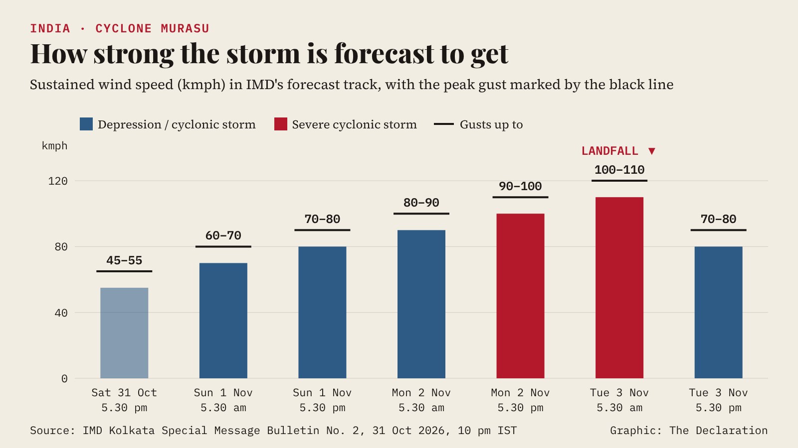
The depression over the southeast Bay of Bengal is now expected to become a severe cyclonic storm before it crosses the south Andhra Pradesh coast between Nellore and Narsapur on the morning of Tuesday, 3 November, with sustained winds of 100 to 110 kmph gusting to 120 kmph, the India Meteorological Department (IMD) said in a bulletin issued at 10 pm IST on Saturday.
That is a step up from the IMD's forecast earlier on Saturday, when the storm was expected to reach only cyclonic-storm strength, with winds of 80-90 kmph gusting to 100 kmph, and no landfall point had been named. Once the system becomes a cyclonic storm, expected on Sunday, it will be named Murasu, a name proposed by India.
What happened
At 5.30 pm IST on Saturday the depression lay near latitude 10.5°N and longitude 88.6°E, about 960 km east-southeast of Chennai, 980 km southeast of Visakhapatnam, 1,030 km southeast of Machilipatnam and 1,080 km east-southeast of Ongole, according to the special bulletin issued by the IMD's Regional Meteorological Centre in Kolkata. It was moving west-northwest at about 30 kmph.
The IMD expects it to become a deep depression by midnight on Saturday, a cyclonic storm over the southeast Bay of Bengal on Sunday, 1 November, and a severe cyclonic storm over the west-central Bay on Monday, 2 November. It should be near the south Andhra Pradesh coast in the early hours of Tuesday, then cross the coast that morning.
The bulletin's track table shows winds rising from 45-55 kmph on Saturday evening to 80-90 kmph by early Monday and 100-110 kmph, gusting to 120 kmph, by 5.30 am on Tuesday. After landfall the system is forecast to weaken quickly over land, to a cyclonic storm by Tuesday evening and a depression by Wednesday as it moves inland towards the north-northwest.
What it means for Bengal
The Kolkata bulletin says there is "at present no weather warning for West Bengal" linked to the system, which it is keeping under watch. A Distant Cautionary Signal No. 1 has been hoisted at the Kolkata and Haldia ports, with a sectional signal at Sagar Island. A distant cautionary signal warns ships leaving port that a storm system lies far out at sea; it does not indicate danger to the port itself.
Until 8.30 am on Sunday, the IMD expects light to moderate rain at a few places in south Bengal, with thunderstorms, lightning and gusts of 30-40 kmph at one or two places in Kolkata, North and South 24 Parganas, East Burdwan, Birbhum, Murshidabad and Nadia. Light rain at one or two places is likely across south Bengal until Tuesday morning, followed by dry weather from 4 to 7 November. In north Bengal, Darjeeling, Kalimpong, Jalpaiguri, Alipurduar and Cooch Behar may see thunderstorms and gusty wind until Sunday morning, then light rain.
There is no fishing warning for the Bengal coast, but the IMD has advised Bengal's fishermen not to go towards the west-central and adjoining northwest Bay of Bengal or the south Odisha coast from 2 to 4 November.
Odisha and the south brace again
Southern Odisha is still recovering from Cyclone Arnab, which brought extreme rain of up to 546 mm at Patrapur in Ganjam district and forced tens of thousands of people from their homes, Pragativadi reported. The IMD expects squally winds of 40-50 kmph, gusting to 60 kmph, along and off the south Odisha coast from Monday evening, rising to 50-60 kmph, gusting to 70 kmph, on Tuesday, with rough to very rough seas until Wednesday afternoon.
IMD Bhubaneswar has issued an orange warning for heavy to very heavy rain in Rayagada, Koraput, Malkangiri, Gajapati and Ganjam on 3 and 4 November, Argus reported. In Ganjam, officials were told to move people out of flood-prone, low-lying areas by Saturday night and to pre-position food, drinking water and generators in villages likely to flood, with NDRF and Odisha disaster response teams being stationed in sensitive areas, according to Pragativadi. Schools across Ganjam will stay shut until 3 November, The News Insight reported. Ganjam's fishermen have been told not to go to sea from 2 to 4 November.
In Andhra Pradesh, the State Disaster Management Authority has forecast moderate to heavy rain in several parts of south coastal Andhra and Rayalaseema over the next three days, The Week reported. Tamil Nadu's regional meteorological centre expects rain across the state from 1 to 6 November, and Kerala has yellow alerts in several districts from Sunday to Wednesday.
Background
Murasu would be the second cyclonic storm over the Bay of Bengal this season after Arnab, which has since weakened over southeast Uttar Pradesh. The IMD has named a wide stretch of coast for now and usually narrows the landfall point as a storm approaches and its track becomes clearer.
The forecast upgrade came within hours of the depression forming. On Saturday morning the system was still a low-pressure area over the Andaman Sea; by evening the IMD was forecasting a severe cyclonic storm, the category below a very severe cyclonic storm on its scale.
What happens next
The Kolkata centre said its next update will come on Sunday. The IMD's national cyclone warning centre issues bulletins several times a day once a depression forms, and will name the storm when it reaches cyclonic-storm strength. Ports and fishermen along the Andhra, Tamil Nadu and Odisha coasts should follow the IMD's district and port warnings, which will be revised as the storm nears land.
Key numbers
Landfall: south Andhra coast between Nellore and Narsapur, morning of 3 November
Peak forecast wind: 100-110 kmph, gusting to 120 kmph
Distance from Chennai at 5.30 pm Saturday: about 960 km
Speed of movement: about 30 kmph, west-northwest
Bengal: no warning; Distant Cautionary Signal No. 1 at Kolkata and Haldia ports
Sources
- Original documentIMD Kolkata: Special Message Bulletin No. 2, "Depression over Southeast Bay of Bengal", 31 Oct 2026, 22:00 IST (PDF)
- Argus: Cyclone Murasu likely to form tomorrow; IMD says severe storm may hit Andhra coast on November 3
- Argus: Cyclone Murasu threat, heavy to very heavy rain forecast in flood-hit south Odisha
- Pragativadi: Ganjam on high alert as district gears up for fresh cyclonic threat
- The Week: After Arnab, Cyclone 'Murasu' headed to Andhra Pradesh
- The News Insight: TNI evening news headlines, October 31, 2026
This story was researched and drafted with AI assistance and reviewed by an editor before publication. Spotted an error? Tell us. Corrections log.